Road construction
Stay informed about ongoing and upcoming construction projects in your area, including major projects that may affect your commute
Image
Renew London is the City’s program for maintaining and improving infrastructure across the city. This includes roads, bridges, sidewalks, bike lanes, sewers, water pipes, and intersections.
As London grows and weather events put more stress on infrastructure, upgrades are needed to keep everyone safe and moving efficiently. London is one of Ontario’s fastest growing cities, and new homes need water services and road infrastructure. We also need to ensure our existing roads, pipes, and bridges stay safe and maintained.
Each year, the City plans construction to make important upgrades while minimizing traffic disruptions where we can. In the spring, our annual Renew report to Council shares a summary of last year’s work and what’s planned for the coming year.
The City also highlights our Top 10 projects annually to show the biggest and most important construction work. As part of the program, the City shares a yearly infrastructure map, showing all planned projects by ward. Click the button below to view the 2026 Infrastructure map.
Below is the list of the top 10 construction projects for 2026, which are making the largest improvements, involve the most complex work, and have the greatest traffic impacts.
You can explore these projects in more detail on our interactive map. Click here to view the map.
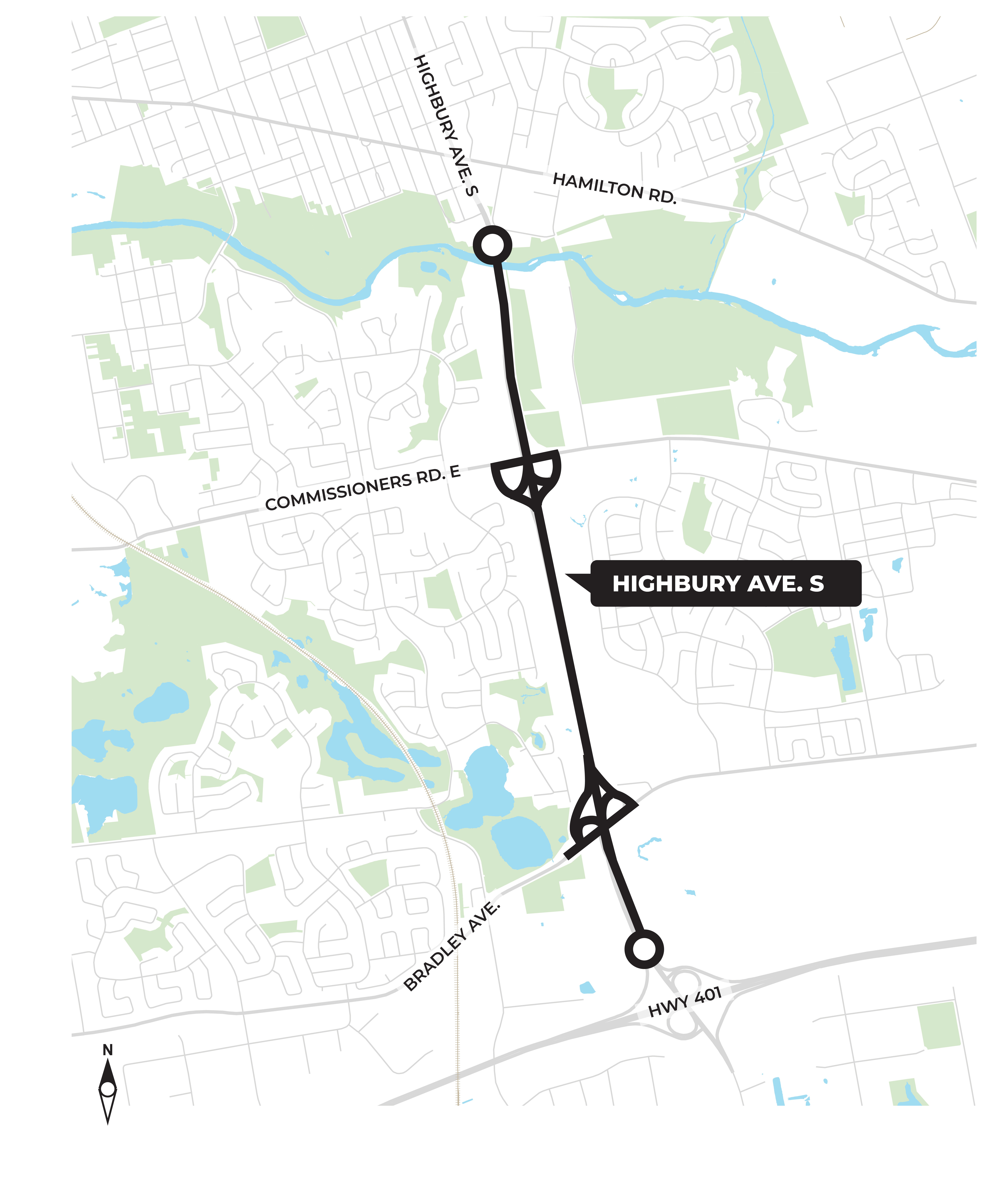
We’re repairing and upgrading Highbury Avenue from the Thames River to Highway 401, including important bridge work at Commissioners Road and Bradley Avenue.
These improvements will make travel safer and more efficient between London, and Highway 401, helping to support regional economic growth and future development.
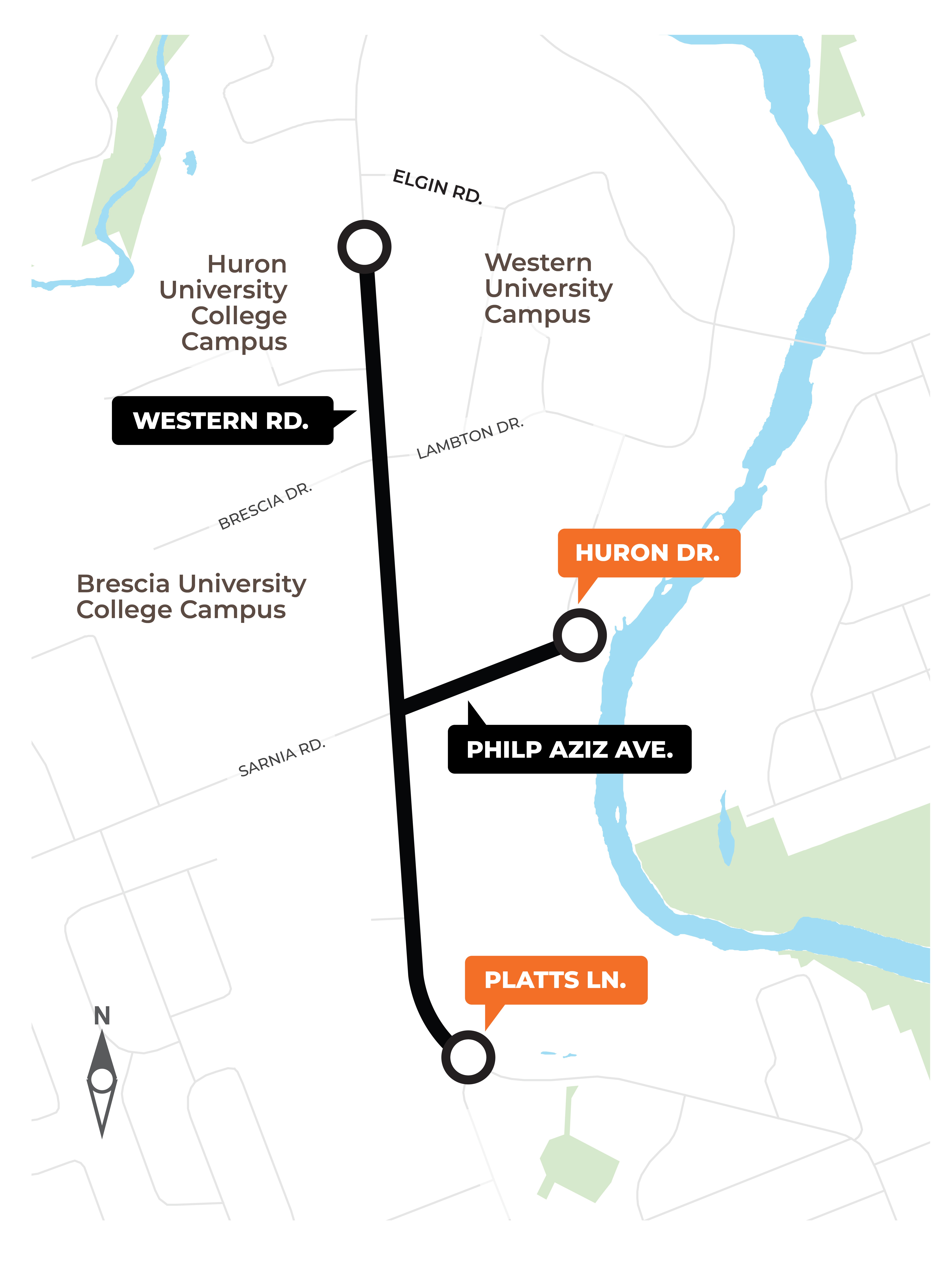
We’re making intersection and road upgrades on Western Road from Platt’s Lane to Burnlea Walk, and on Philip Aziz Avenue from Western Road to the Thames River.
These improvements will make the area around Western University safer and easier to travel for drivers, cyclists, and pedestrians.
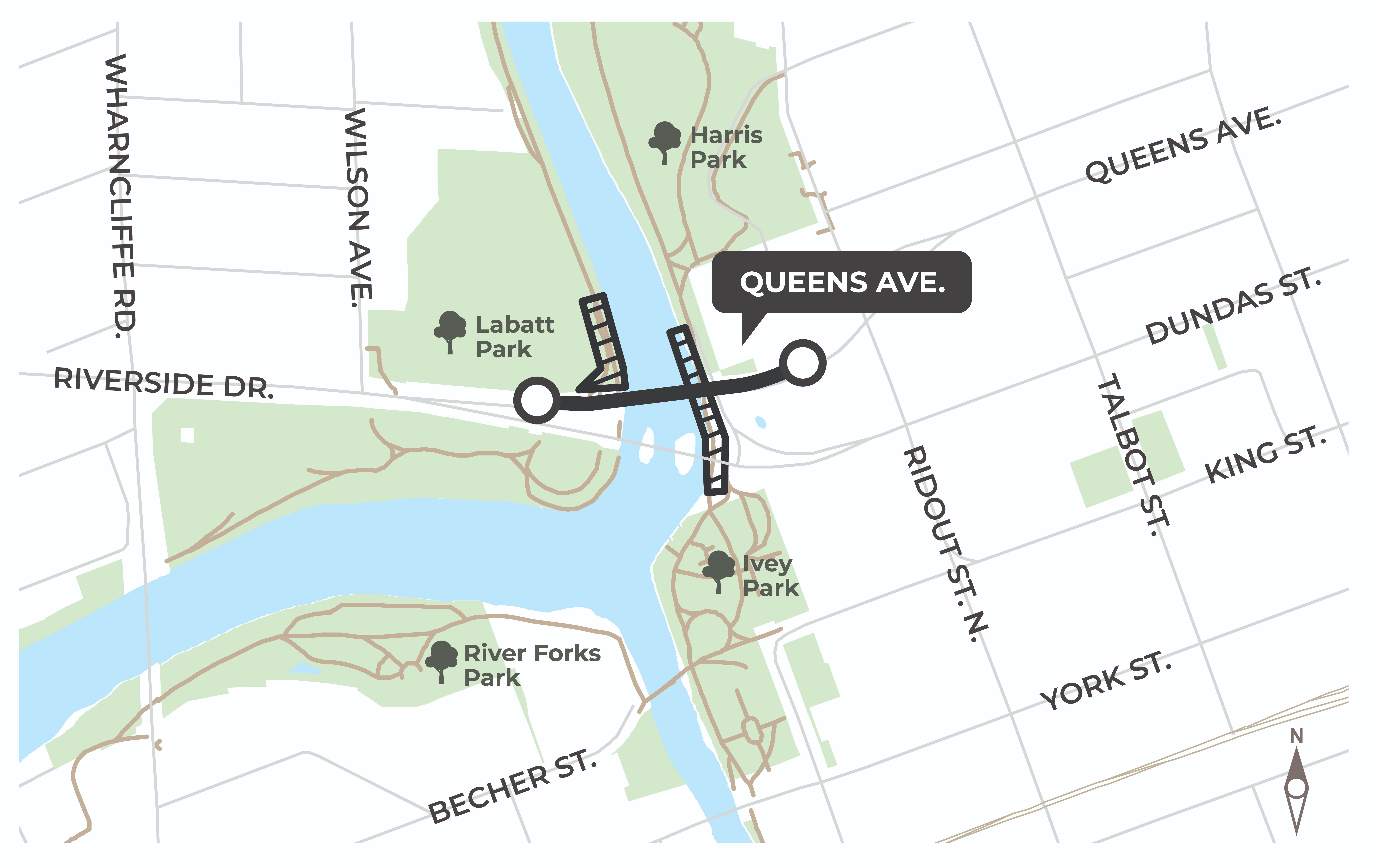
We’re repairing the Queen’s Bridge on Queens Avenue, from Ridout Street North to Wilson Avenue, and improving the east shoreline of the Thames River beneath Queen’s Bridge and Kensington Bridge.
This project will rebuild the bridge deck and key structures, add a multi-use path for walking and cycling, upgrade pedestrian crossings, and strengthen shoreline protection for a safer, more accessible, and resilient riverfront.
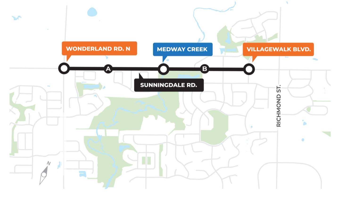
To improve traffic flow in this growing part of the city, we’re widening Sunningdale Road from Wonderland Road to Villagewalk Boulevard and adding active transportation upgrades.
The project will expand the road, enhance safety for all users, and support future development in northwest London.
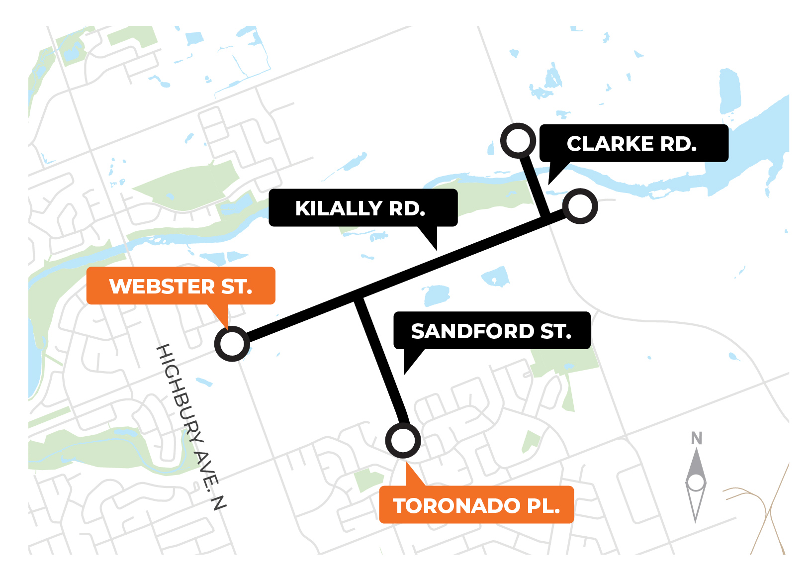
We’re upgrading underground pipes and services along Kilally Road, from Webster Street to Clarke Road, in this growing part of the city.
These improvements will modernize the road and surrounding corridor, making it safer and easier for walking, cycling, and other active transportation, while supporting future growth.
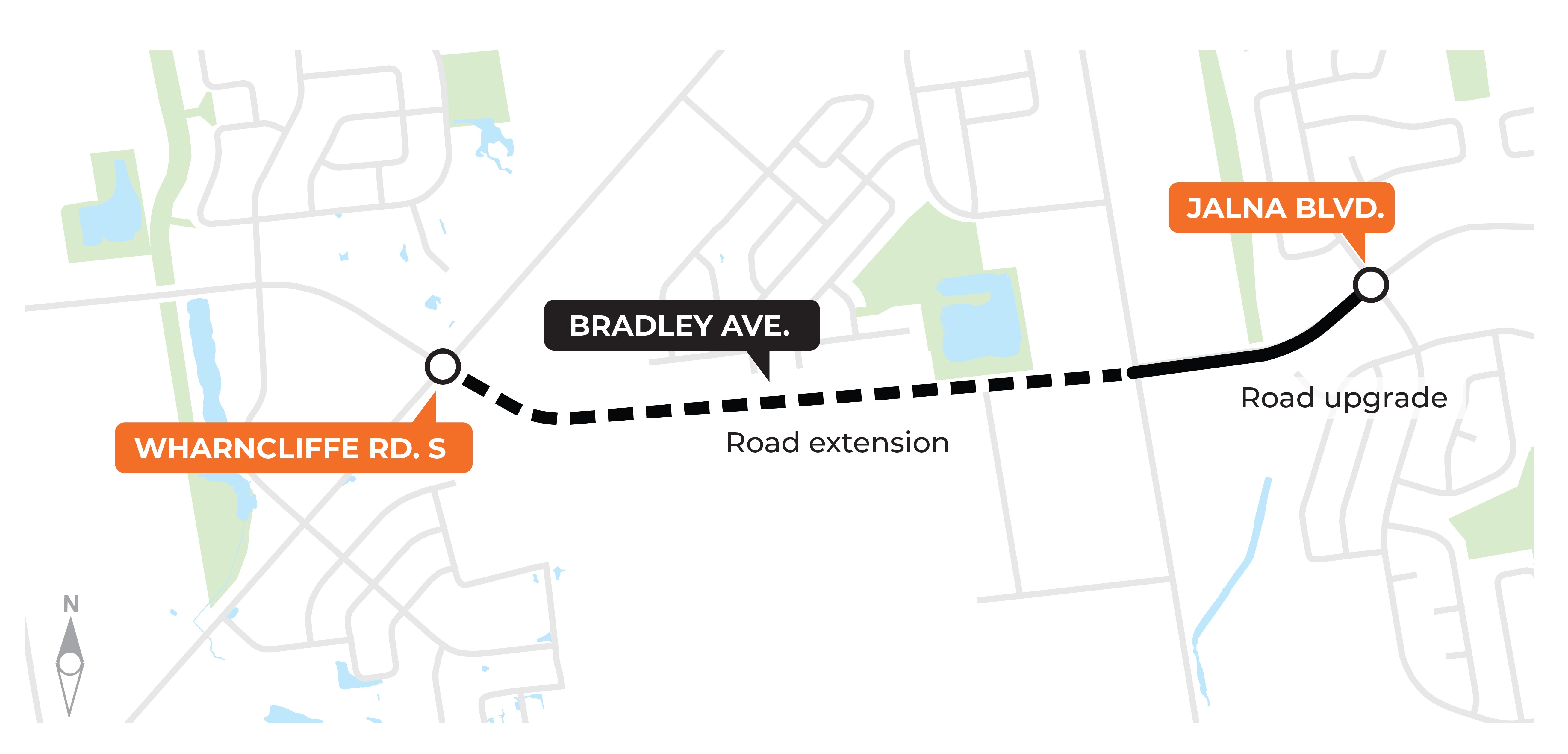
We’re extending Bradley Avenue and making road upgrades from Wharncliffe Road South to Jalna Boulevard.
This project will complete an important road connection, improving mobility and supporting growth across the city.
We’re constructing part of the Wellington Gateway Rapid Transit route while upgrading underground pipes and services on Wellington Road between Watson Street and Wilkins Street.
This final stage of the south Rapid Transit corridor include upgrades to the road, transit infrastructure, and underground services, improving travel and preparing the city for the future.

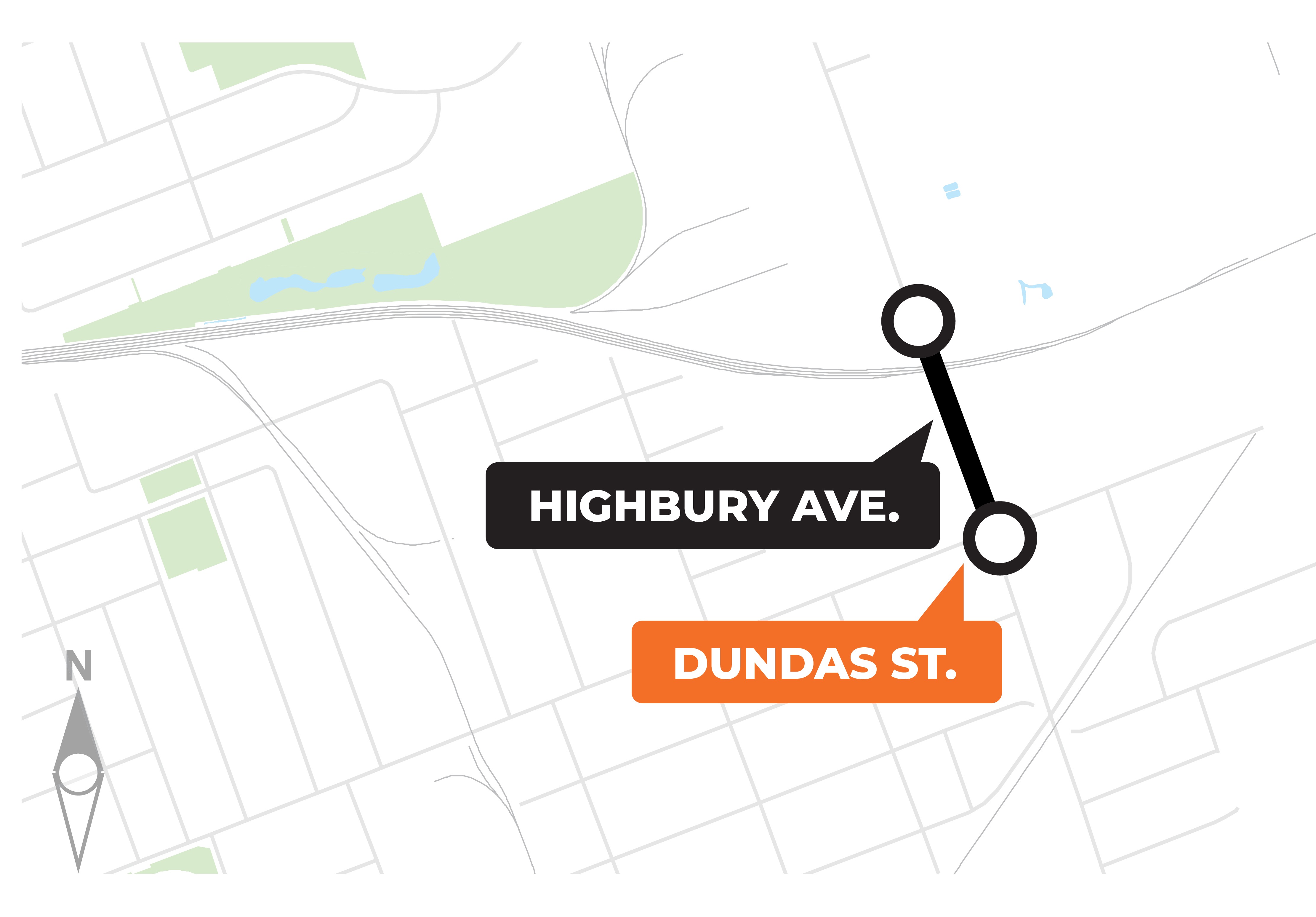
We’re constructing a section of the East London Link Rapid Transit route while upgrading underground pipes and services on Highbury Avenue, from Dundas Street to the north limit of the Highbury Bridge/CPKC overpass.
This project replaces aging bridge structures, improves regional connections, and supports transit infrastructure for a safer, more reliable transportation network.
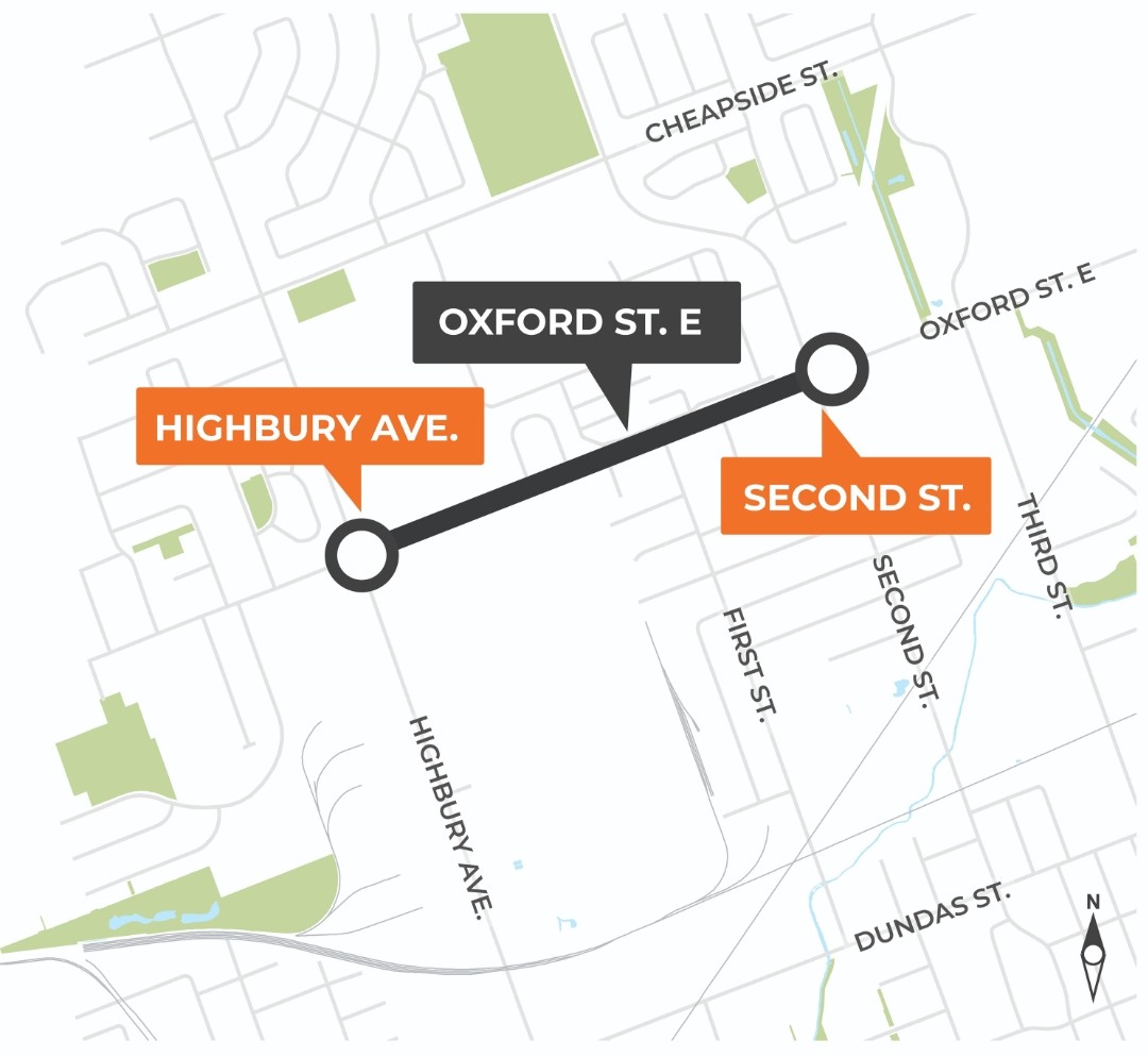
We’re constructing a section of the East London Link Rapid Transit route while upgrading underground pipes and services on Oxford Street between Highbury Avenue and Second Street.
This project continues work along the corridor, improving the roadway, active transportation options, and transit facilities for safer and more efficient travel.
We’re constructing a section of the East London Link Rapid Transit route while upgrading underground pipes and services on Dundas Street, between Egerton Street and McCormick Boulevard.
This final phase completes the East London Link corridor, enabling full Rapid Transit operations and supporting growth and development in the surrounding area.

Most construction projects have dedicated Get Involved pages, where Londoners can learn more, ask questions, and provide feedback.
Stay up-to-date on construction projects that affect you by clicking the button below.
Each year, the City of London identifies high-priority areas and develops a sidewalk plan. Building new sidewalk connections make communities more accessible for everyone, regardless of age or ability.
Each year, the City of London identifies and undertakes projects to build new cycling connections and to enhance the existing active transportation network across the city.
The Local Road Reconstruction program rebuilds neighborhood streets from the ground up. This fixes old or damaged roads and updates sidewalks, curbs, and drainage to improve safety and accessibility. Below are the list of 2026 projects.
Renew is an interactive map showing ongoing and planned construction across London. It highlights road closures, lane restrictions, and other traffic impacts.
The Renew London map lets you see all projects planned and underway, making it easy to track construction, plan your daily commutes, and staying informed.
You can search by street name to see what work is happening and when, helping you plan your travel.
Note: Renew also shows construction not managed by the City of London, such as private utility work by hydro, gas, water, or telecommunications companies. These projects may affect streets, sidewalks, or traffic.
The Renew map is below, so you can explore projects and plan your trips around construction in real time.
Search and explore: Use the search function in the top left corner (or at the top on mobile) to enter your home address, work address, or other locations. This will show construction happening nearby.
Click on construction areas: Click on points on the map to see details about the work, including expected duration and traffic impacts.
Use the drop-downs: At the bottom of the map, there are three drop-downs where you can view road closures, ongoing construction, and upcoming construction. Click on any project to see full details, including road impacts and other important information.
You can report an issue by contacting Service London.
During construction, you may report things like:
A City program that keeps London’s roads, bridges, sidewalks, and underground utilities in good working condition. It plans and schedules upgrades, so infrastructure lasts longer and stays safe for everyone.
Rebuilding neighborhood streets from the ground up. This fixes old or damaged roads and updates sidewalks, curbs, and drainage to improve safety and accessibility.
Upgrading major roads that carry a lot of traffic. This work improves traffic flow, safety, and durability for vehicles, transit, cyclists, and pedestrians.
Updating traffic lights and related systems to help vehicles, buses, and pedestrians move more efficiently and safely through intersections. To learn more about traffic, pedestrian and bicycle signals click here.
An intersection improvement makes changes to an intersection such as new traffic signals, turn lanes, or crosswalks to make it safer and easier for drivers, cyclists, and pedestrians.
Installing new sidewalks or replacing old ones to make walking safer and more accessible for everyone, including people with mobility needs.
Construction or upgrades to drains, pipes, and channels that carry rainwater. These projects help prevent flooding, reduce water pooling on streets, and protect homes and businesses.
Information for consultants and contractors is available online. This includes the Standard Contract Documents for Municipal Construction.