The City is committed to making our roads safer for everyone by developing clear local strategies and adopting global best practices.
The City has initiated the development of “Safe Mobility Action Plan (SMAP)” to provide an update to the current document:
Vision Zero
Vision Zero is global movement dedicated to eliminating all traffic deaths and injuries, while increasing safe, healthy, equitable mobility for all.
London City Council has adopted the following Vision Zero principles:
- no loss of life is acceptable
- traffic fatalities and serious injuries are preventable
- we all make mistakes
- we are all physically vulnerable when involved in motor vehicle collisions
- eliminating fatalities and serious injuries is a shared responsibility between road users and those who design and maintain our roadways
Road safety in London
The City initiates a number of road safety campaigns to take measurable action and implement Vision Zero principals.
Active and safe routes to school
Educational videos, resources, and information for parents, students, and teachers are available online to help teach kids to walk, bike, and roll to school.
Active school travel such as walking, biking, and scootering to and from school and the school bus stop, helps to:
- Improve physical and mental health
- Reduce traffic around schools
- Improve air quality and the environment
- Have students feel more connected to their community, is fun, and social.
Active and Safe Routes to School is led by a group of community partners, including the City of London, working together to promote programs that encourage children and families to choose active transportation to travel to school.
Area speed limits
The City is working to make our streets safer for all road users by lowering speed limits on roads with high pedestrian and cycling usage.
Automated Speed Enforcement
The Province of Ontario’s Bill 56 – Building a More Competitive Economy Act – has now come into effect, prohibiting the use of automated speed enforcement (ASE) cameras across all municipalities as of November 14, 2025. In response to this legislative change, the City has removed seven ASE cameras and related signage across the City of London.
Road safety remains a top priority for the City. London will continue to monitor provincial guidelines and will adapt our road safety programs to ensure safe roads for everyone.
On November 14, 2025, the Province shared details about a new Road Safety Infrastructure Fund (RSIF), which includes $210 million in funding for traffic-calming measures in school zones and community safety zones in Ontario. These measures may include speed bumps, raised crosswalks, and enhanced signage.
An initial RSIF allocation of $42 million is being made available immediately to support traffic-calming measures in school zones and community safety zones that previously deployed municipal speed cameras. Civic administration will be working with the Province to access London’s allocation of the initial immediate funding which has been identified as $1.29 million.
Any concern about speeding on local roads can be reported to Service London via this link: Report a Traffic, Cycling, or Streetlight Concern.
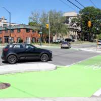
Green paint in bike lanes

The City is painting some bike lanes green as a way to increase safety. These high-visibility lanes are designed to remind motorists to watch for cyclists and share the road. Mind the green is a campaign to help educate people about the presence of bike lanes in our community.
Leading Pedestrian Intervals
Some traffic signals in London are being updated with an advance “walk” signal. The advance “walk” signal provides pedestrians with an additional 5 seconds, to get a head start before vehicles receive a green light, called a Leading Pedestrian Interval.
Leading Pedestrian Intervals improve safety by:
- Enhancing the visibility of pedestrians at intersections
- Providing an earlier time for people with disabilities to start crossing
- Reinforcing pedestrian’s right-of-way over drivers who are turning
Currently, Leading Pedestrian Intervals are implemented at the following locations:
- Intersection of Dundas and Ridout
- Intersection of Dundas and Talbot
- Intersection of Dundas and Clarence
- Intersection of Dundas and Wellington
- Intersection of Windermere and Perth
Pedestrian crossovers
Pedestrian crossovers are designated areas for pedestrians to safely cross the road while vehicles yield. They have specific pavement markings and crossing signs.
Pedestrians have the right of way at these crossovers. Drivers and cyclists must stop behind the yield line and wait until pedestrians completely cross the road before proceeding.
Drivers and cyclists may face a fine in the range of $150 to $500 for not yielding at pedestrian crossovers, and drivers may also face three demerit points.
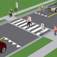
Protected intersections
The addition of protective concrete barriers at intersections provide more space for cyclists and pedestrians, reduce the distance to cross the intersection, and help reduce vehicle traffic speed. Together, these design elements create a safer experience for everyone. The added space also positions cyclists further ahead in the intersection making people on bikes more visible to drivers waiting at a red light.
Protected bike lanes
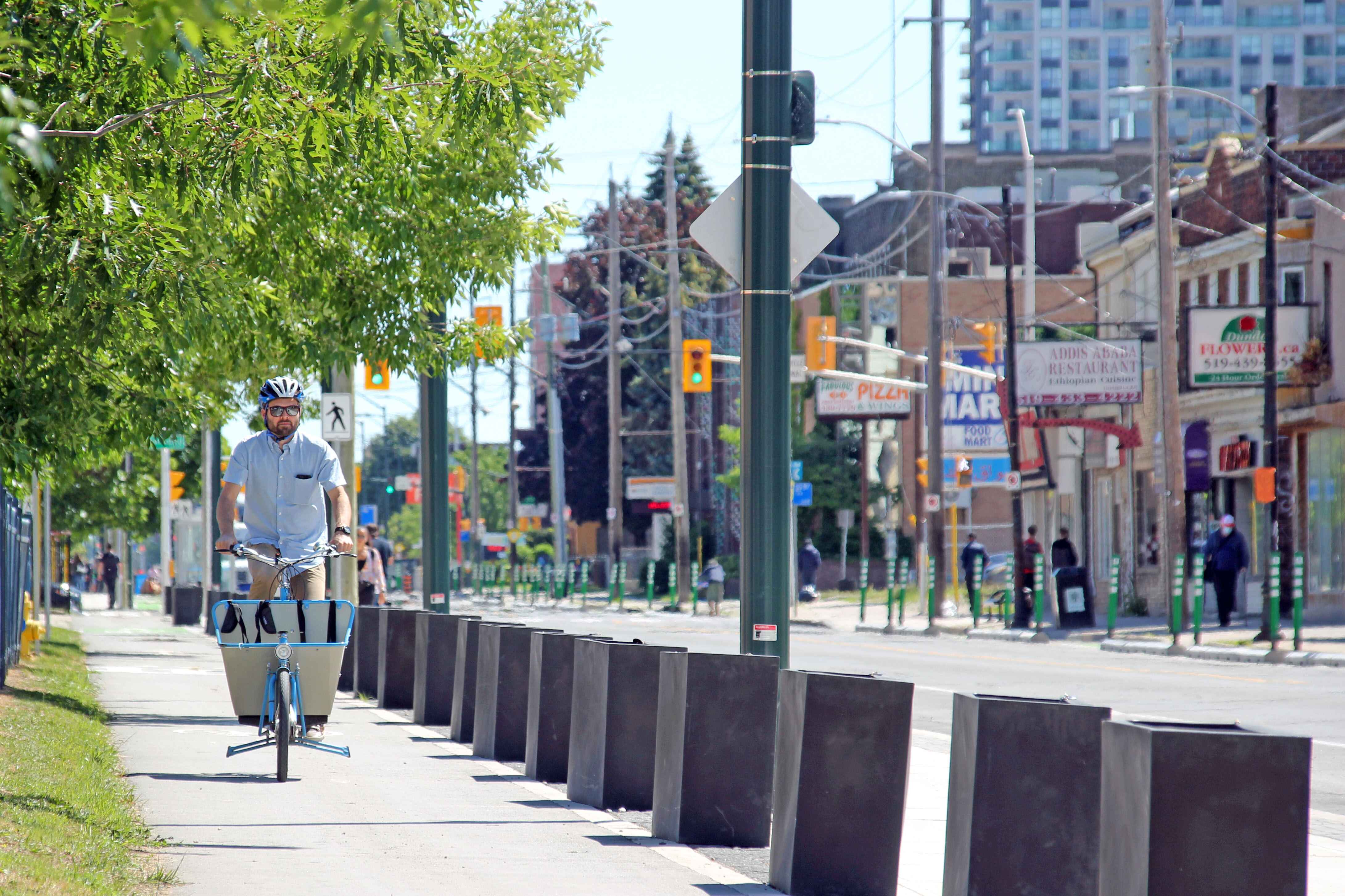
Protected bike lanes are physically separated from motor vehicle traffic and distinct from the sidewalk. Protected bike lanes are narrower than traffic lanes and typically installed along a curb. There are a variety of methods used to provide physical protection for cyclists from passing traffic such as planters or concrete curbs with bright green bollards.
Protected bike lanes make it safer and easier for everyone to get around, by providing clearly defined areas for cyclists.
Red light cameras
Motorists running red lights account for hundreds of collisions each year in our city. Red light cameras are one tool the City uses to help reduce collisions at intersections.
Respect the limit signs
Respect the limit is a campaign designed to raise awareness about the dangers of driving too fast.
Lawn signs are available at the main floor of City Hall for residents to place on their front lawns.
Roundabouts
A roundabout is a circular intersection where two or more roads meet. Traffic circulates through them counter-clockwise, to the right of a centre island. Roundabouts create lower speeds reducing the potential for serious crashes and injuries.
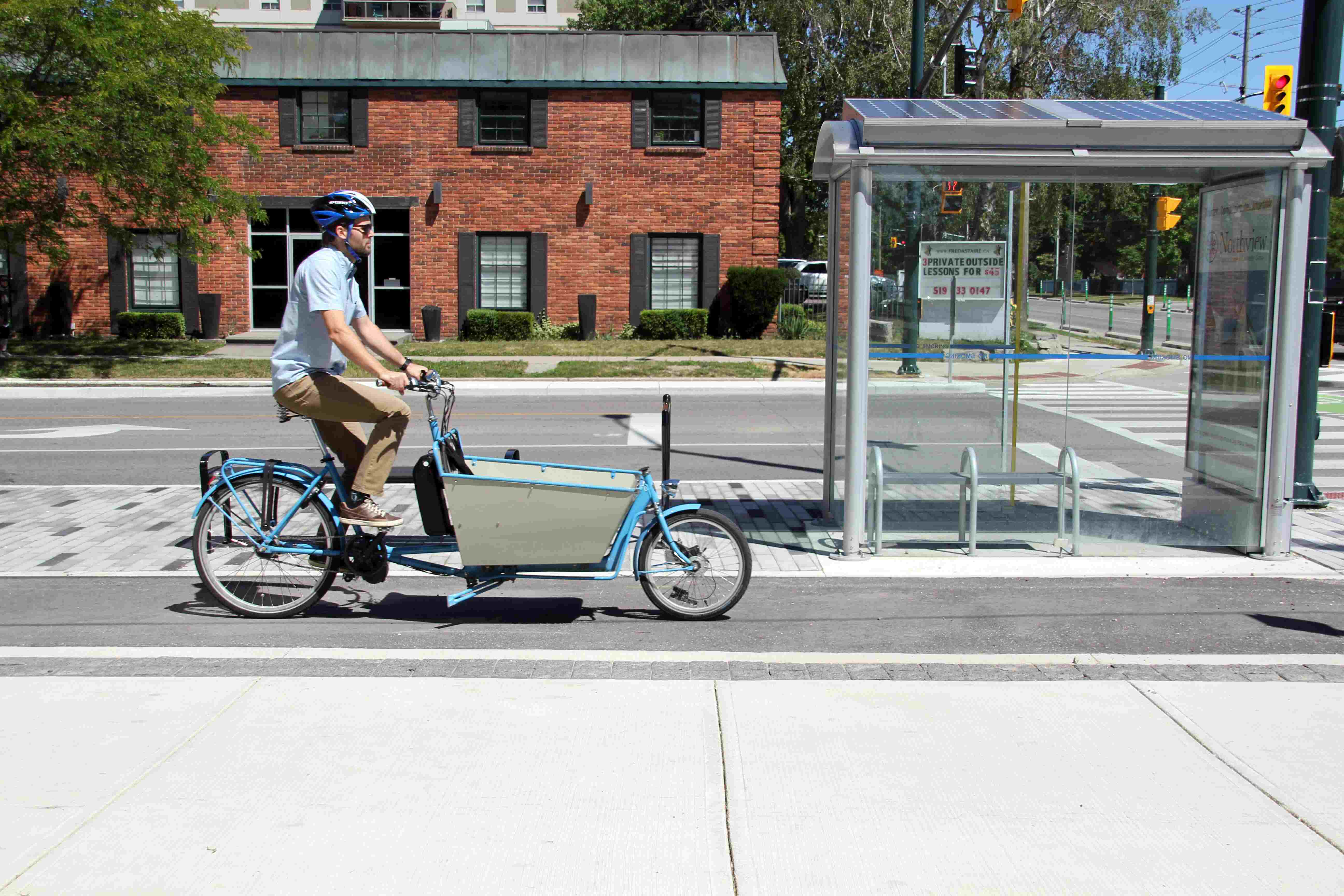
Shared transit stops

Shared transit stops combine a transit stop with a protected bike lane. These shared spaces are designed to keep cyclists protected from vehicle traffic while providing space for transit riders to get on and off the bus.
Bicycle lanes ramp up to platform height before the stop, and then ramp down after. Cyclists approaching the bus stop must stop when passengers are boarding or getting off the bus, and should remain stopped until the bus signals that it is leaving the stop.
Student silhouettes

To help promote safe conditions and address driving behaviours in areas where students are often seen walking to and from school, the City of London is installing life-size student silhouettes to heighten drivers’ awareness that they are travelling within a school zone.
Student Silhouettes have been identified as an effective visual tool that reminds drivers to slow down and take extra caution in areas with lots of children.
Signs are placed alongside the road, at school zone entry and exit points. These entry and exit points also mark the beginning and end of the 40km/hr school zone speed limit.
Student Silhouettes are being used as one of many tools to raise awareness of residential speeding in London. Signs will be rotated to a new school zone location every 3 to 4 weeks.
For more information about Student Silhouettes, please contact Jeff Jongsma at jjongsma@london.ca or call 519-661-2489 x 4736
Turning right? Yield to bikes

Drivers turning right must yield to cyclists. With more people cycling along bike lanes in London, remember to look and stop to allow people to ride by before you turn right in your vehicle.
As a driver, always remember to check for cyclists when crossing a bike lane to turn or park. Yield to cyclists when turning right, and never park in a bike lane.
Transit islands
Transit islands use a combination of tactile warning strips, pavement markings and signage to guide people across the bike lane to the transit island where they can wait, board and/or get off the bus.
These new bus stops keep cyclists protected from vehicle traffic, allow more space for benches, shelters, and passengers waiting for the bus, and offer more room to pedestrians using the sidewalk. When cyclists approach the bus stop, they must stop to let pedestrians cross the bike lane.
Zipper merge
The zipper merge is a late merge strategy where all available lanes of traffic are used right up to the lane closure. Drivers then alternate into the open lane. The zipper merge strategy is most effective when there are high traffic volumes on the road, combined with low average speeds due to congestion.